Abandoned Places: 60 stories of places where time stopped


COPYRIGHT
ABANDONED PLACES
Published by Collins
An imprint of HarperCollins Publishers
Westerhill Road
Bishopbriggs
Glasgow G64 2QT
www.harpercollins.co.uk
FIRST EDITION 2015
© HarperCollins Publishers 2015
Text written by Richard Happer 2015
Collins® is a registered trademark of HarperCollins Publishers Ltd
A catalogue record for this book is available from the British Library.
All rights reserved under International and Pan-American Copyright Conventions. By payment of the required fees, you have been granted the nonexclusive, nontransferable right to access and read the text of this e-book on-screen. No part of this text may be reproduced, transmitted, downloaded, decompiled, reverse-engineered, or stored in or introduced into any information storage and retrieval system, in any form or by any means, whether electronic or mechanical, now known or hereafter invented, without the express written permission of HarperCollins e-books.
The contents of this publication are believed correct at the time of printing. Nevertheless the publisher can accept no responsibility for errors or omissions, changes in the detail given or for any expense or loss thereby caused.
HarperCollins does not warrant that any website mentioned in this title will be provided uninterrupted, that any website will be error free, that defects will be corrected, or that the website or the server that makes it available are free of viruses or bugs. For full terms and conditions please refer to the site terms provided on the website.
Source ISBN: 9780008136598
Ebook Edition © AUGUST 2015 ISBN: 9780008165079
Version: 2015-08-28
10 9 8 7 6 5 4 3 2 1
If you would like to comment on any aspect of this book, please contact us at the above address or online:
email: collinsmaps@harpercollins.co.uk


Cover Image: Inside Buzludzha Monument
© Dimitar Dilkoff/AFP/Getty Images
CONTENTS
Places listed chronologically by the approximate date by which they became abandoned
Cover
Title Page
Copyright
Petra
Machu Picchu
Easter Island
Ani
Mandu
Ross Island
Stelling van Amsterdam
Kayaköy
Sonargaon
St Kilda
Bokor Hill Station
Red Sands Sea Forts
Bodie
Tyneham
Oradour-sur-Glane
Giersdorf Church
Graun
Waiuta
Kolmanskop
Detroit
Lion City
Humberstone & Santa Laura
Chinguetti
North Brother Island
Craco
Chittagong
L’Île-aux-Marins
Leith Harbour & Grytviken
Wittenoom
Poveglia
Canfranc Station
Eastern State Penitentiary
Varosha
Hashima Island
Tatooine
Sanzhi UFO Houses
Millennium Mills
Buzludzha Monument
Epecuén
Pripyat
Centralia
Young Pioneer Camp
Juragua
Rosario Island Villas
London Underground Stations
Plymouth
Hotel del Salto
Beelitz Sanatorium
Objekt 825
Sathorn Unique
Macassar Beach Pavilion
Pyramiden
Larundel Asylum
Saddam’s Palaces
Mirabel Airport
Athens Olympic Venues
Six Flags Jazzland
Tampico
Nara Dreamland
Kangbashi New Area
Index
About the Publisher

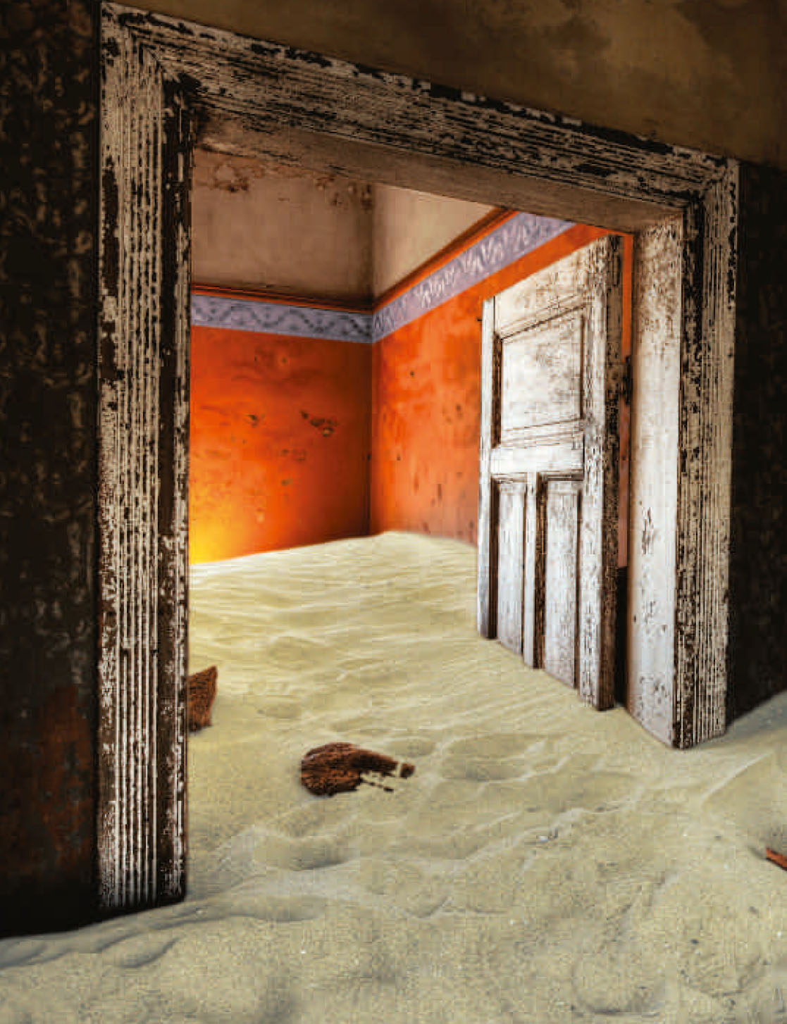
From Antarctic bays bound by a frozen sea to the most parched deserts on earth, from monsoon-drenched estuaries to wind-whipped Atlantic islands, there are places that humans have settled, thrived in, and then abruptly departed from. These abandoned places lie deep underground, on the highest mountain tops, in the middle of our biggest cities, in our suburbs, on our doorsteps. They are all around us, but most of the time we pass them by. Yet when we take the time to look, to explore, we find new worlds that are endlessly fascinating. What brought people to this place? How did they survive? What was life here really like? Perhaps most intriguingly of all – why did they leave?
That question is answered in myriad ways. War. Natural disaster. Economic pressure. Fashion. Political gamesmanship. Greener grass elsewhere. Human foolishness. Every derelict settlement is an empire in miniature that tells its own story of glorious rise and humble fall. Here we present sixty of those intriguing tales, illustrated with photographs that perfectly capture the haunting echoes of lives long forgotten. If there can be no true beauty without decay, then these abandoned places are, in their way, some of the most beautiful places on earth.
PETRA
DATE ABANDONED: AD 663
TYPE OF PLACE: City
LOCATION: Jordan
REASON: Environmental/Economic
INHABITANTS: 20,000
CURRENT STATUS: UNESCO World Heritage Site
THREE CENTURIES BEFORE CHRIST’S BIRTH, A TRIBE OF NOMADS DECIDED TO CUT THEMSELVES A CITY FROM BARE ROCK. ABANDONED AND LOST FOR A MILLENNIUM, THEIR CAPITAL WAS REDISCOVERED IN THE NINETEENTH CENTURY AND IS NOW RECOGNIZED AS ONE OF THE WORLD’S OUTSTANDING CULTURAL WONDERS.
The rose-red city half as old as time
It is called Petra in Greek and Sela in Hebrew; both mean ‘rock’ and few places have as simple and as beautifully apt a name. For this city that once housed 20,000 prosperous souls was carved out of, and into, the red sandstone cliffs of a desert gorge over 2,000 years ago.
Most abandoned places have a short life. It is the very nature of their derelict existence: they have been let go, lost, left to the entropic power of nature. Petra, however, is almost as magnificent now as it was two millennia ago.
It is mentioned twice in the Bible and Arab tradition maintains that Petra is where Moses (Musa) struck his staff on a rock and water came forth. Even then it was a wonder: one of the wealthiest cities in the ancient world flourishing in one of the harshest climates on earth. Today it is a magnificently preserved picture of an ancient civilization and a thrilling reminder that not everything we abandon need be lost.
The wanderers settle down
The Nabataeans were originally nomadic spice traders of the south Levant and north Arabia. They controlled a loosely structured trade network with oases as hubs linked by caravan routes through the surrounding desert.
Around 300 BC, they decided to develop a more state-like kingdom and swiftly constructed Petra as their capital city. The fortress-like location of towering rocks and narrow gullies certainly made for a wonderful defensive site, but there was one major problem: water.
Water management
It may be surrounded on all sides by dry, searing desert, but Petra owes its existence to water. Or rather, to the skill and ingenuity of the Nabataeans in gathering that most precious of commodities and bringing it to their city. When rain does fall here, it creates flash floods that rip through the landscape, carving its distinctive gullies and gorges. For most people that rain would be too rare and too destructive to be of any use.
The Nabataeans thought differently, and they built an ingenious system of conduits, dams, cisterns and pipes to channel and store the rain and spring water from a wide area. This vast plumbing network turned a meagre 15 cm (6 inches) of annual precipitation into a constant water supply that could deliver an estimated 12 million gallons of fresh water a day. In effect, they had created an artificial oasis. Its water supported the people of Petra – and was vital to travellers, which helped make the city rich.
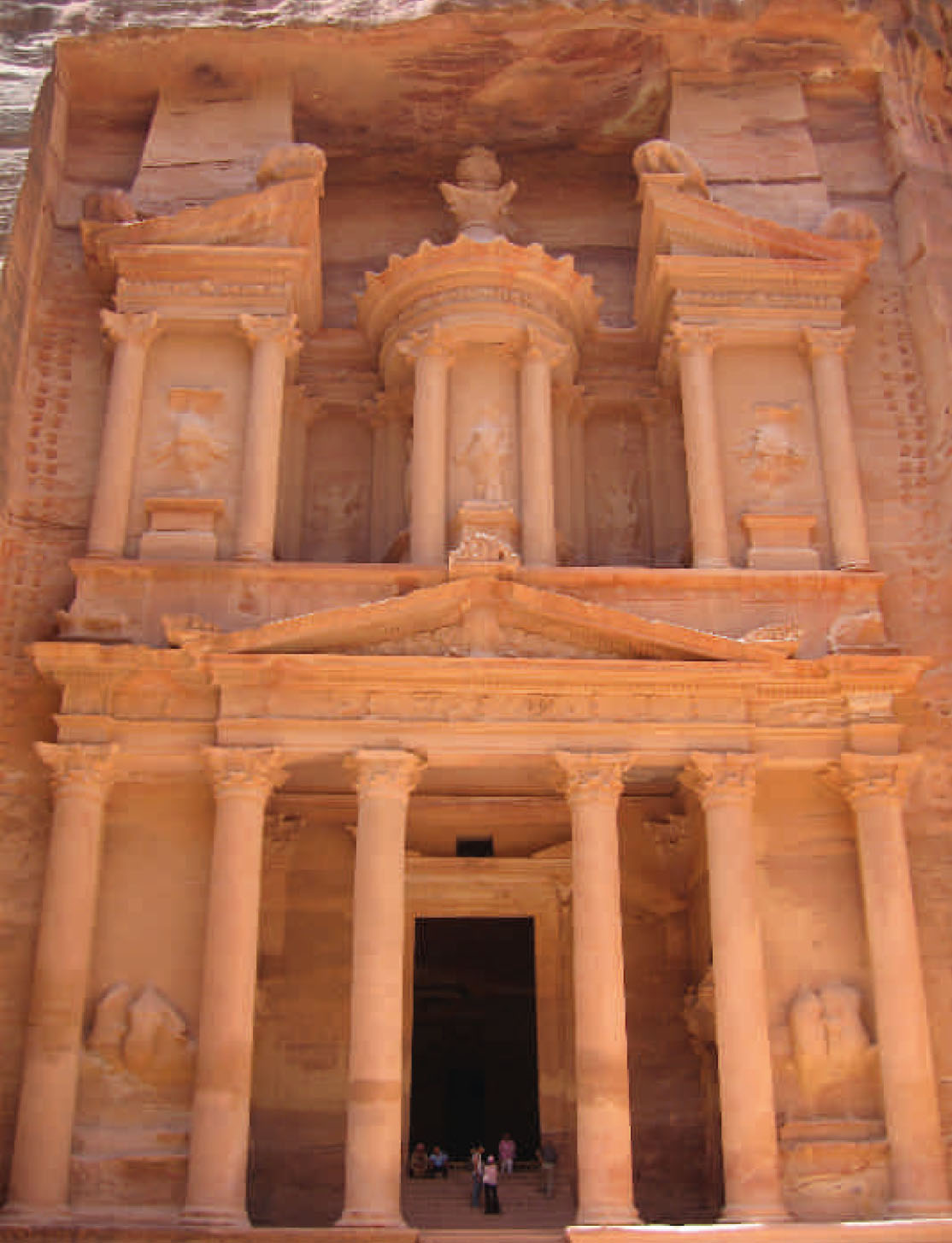
The façade of Al Khazneh (‘The Treasury’) is 40 m (131 ft) high. Its position deep in a gorge has helped protect it from erosion.
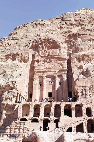
The Urn Tomb, first of the Royal Tombs, is built high up on the mountain side.
Petra was located at the junction of a trade route to Asia and another to Arabia. These were the motorways of their day, along which caravans of 2,500 camels, up to 8 km (5 miles) in length, carried spices, cloth, ivory, metals and incense such as frankincense and myrrh. Petra was an ideal rest and refreshment point for these travellers and, as with any service station, the Nabataeans ensured they profited from their visitors.
By 100 BC the Nabataeans had control of the spice trade and they used their burgeoning wealth to expand their remarkable city. Petra became a metropolis of temples, monuments, altars, houses, and banquet halls carved into the sandstone cliffs. There are 3,000 carved tombs and the open-air theatre could seat 8,000 people.
The rock shakes
Like all empires, the Nabataean dynasty eventually had its fall. Petra was taken within the arms of the Roman Empire in AD 106 and at first flourished in the relationship; the city was at the height of its wealth and influence around AD 200. However, the city of Palmyra gradually drew Arabian trade away from Petra, which declined as a trading hub.
In AD 363 there was a cataclysmic earthquake that cracked beautifully carved facades, brought rocks tumbling from walls and fractured the seats in the theatre. Although people continued to live here, the city never fully recovered from this shock.
By the fifth century the Nabataeans had converted from their own faith to Christianity and Petra became a renowned religious settlement within the Byzantine realm. But by AD 663 even the pilgrims had ceased to come and the city was deserted.
The city lives again
The city slept in its desert canyon for nearly a millennium, forgotten by the wider world. It was rediscovered by an adventurous 27-year-old Swiss traveller, Johann Ludwig Burckhardt, in 1812. He spent years learning fluent Arabic and had disguised himself as a Bedouin to explore as far off the beaten track as possible. Tales of the lost city’s mystical beauty captured the Victorian imagination, and it was famously described as ‘a rose-red city half as old as time’ in a poem by John William Burgon.
In the First World War, Petra was at the centre of an Arabian revolt against the Ottoman regime. British Army officer T. E. Lawrence, better known as Lawrence of Arabia, helped drum up support amongst the Bedouins living in the area to rout the Turkish forces.
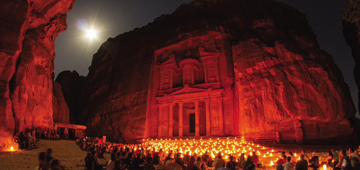
The Treasury by night. Behind the facade is a large square room; Indiana Jones found the Holy Grail inside.
Exploring the site
Few cities on earth have as spectacular an entrance as Petra. It is approached through the Siq, a sinuous gorge that snakes for 1.2 km (0.75 miles) between gloomy cliffs up to 182 m (597 ft) high. In some places the Siq (meaning ‘the Shaft’) is only 3 m (9.8 ft) wide, but this split in the mountain is the main way of accessing the city.
Visitors pad through the sandy darkness to finally emerge in a blinding cathedral of light and come face to face with one of Petra’s most famous monuments: Al Khazneh (‘The Treasury’). This was not a place of business, but rather a crypt built around the time of Christ. It later got its name from a story about bandits who had hidden gold in one of the urns carved high on the facade. Today this urn is pocked with bullet holes made by Bedouins trying to shatter it and release the treasure. In fact, the urn is solid sandstone. The Treasury’s huge pillars and pediment are of Greek influence in their design, like many of the buildings in Petra.
Another spectacular carved building is the monastery (actually a temple), which is cut into a hilltop an hour’s climb from the main city. The scale of the stone-carving here is truly awe-inspiring: the monastery’s huge facade is 50 m (165 ft) square and its doorway is as tall as most houses.
Cut into Petra’s East Cliff are the Royal Tombs, a group of large and impressive facades. In the warm ruby light of late afternoon the whole cliff here seems to shimmer and glow.
The secrets that sleep on
Film lovers will be aware of Petra’s starring role in many motion pictures. These appearances, and its regular inclusion in new ‘Wonders of the World’ lists, have widened its fame and made it one of the best known abandoned places. Today, Petra is the most visited place in Jordan and a UNESCO World Heritage Site.
However, one of the most intriguing things about Petra is how much more of it is yet to be discovered. Only 15 per cent of the city has been explored by archaeologists; the vast majority remains underground and untouched, as it has been since antiquity.
MACHU PICCHU
DATE ABANDONED: Sixteenth century
TYPE OF PLACE: Inca city
LOCATION: Peru
REASON: Disease/Invasion
INHABITANTS: c. 1,000
CURRENT STATUS: UNESCO World Heritage Site
CROWNING A SHEER-SIDED PERUVIAN MOUNTAIN IS MACHU PICCHU, AN EXTRAORDINARY EXPRESSION OF ENGINEERING SKILL AND RELIGIOUS DEVOTION THAT WAS ABANDONED ONLY 100 YEARS AFTER ITS CONSTRUCTION. THE INVADING SPANISH NEVER FOUND THE CITY, BUT THE DESTRUCTION THEY BROUGHT KILLED IT NONETHELESS.

The palace in the peaks
It was a royal Inca estate and religious retreat that just happened to be perched on a precipitous mountain ridge at 2,430 m (7,970 ft) above sea level. Machu Picchu was completed around 1450, and flourished as a self-sustaining stronghold of 1,000 souls for 100 years. Then it was abruptly abandoned during a time of catastrophic population collapse. Today its enigmatic remains are among the most beautiful and spectacular of all lost civilizations.
It’s hard to imagine a site with better natural defensive protection. The Urubamba River encircles the site on three sides, at the bottom of cliffs that drop vertically for 450 m (1,480 ft). On the fourth side is a nearly impassable mountain peak.
There was a secret entrance via rope bridge, known only to the Inca army. If an offensive army were to approach they would be seen miles away. When they arrived they would have an unpleasant climb up a near-sheer, heavily vegetated cliff face. Any attempt to starve out the inhabitants would be doomed to failure – the city had enough arable land within its walls to feed its population four times over, and fresh water is not a problem in this misty, rainy area.
The design of the city itself is ingenious. The high hillsides were cut into terraces, to increase the arable land available and to decrease the incidence of landslides. As well as the agricultural zone, Machu Picchu had an urban area. Here were temples, palaces, workshops, storehouses and homes made of expertly dressed stone. Blocks, some weighing up to 50 tonnes, were cut with millimetre-precision to form faultless joints without the use of any mortar. In many places a small gap has been left in the stonework to allow walls to move and flex in an earthquake, thus absorbing much of the destructive force.
Mountain-worship rituals
Religion was part of the everyday fabric of Inca life and Machu Picchu itself was a physical expression of their beliefs. This was a city-shrine to the gods, a clifftop cathedral that stood in symbiosis with the mountain landscape surrounding it. There are several ‘replica stones’ throughout the city; these have been sculpted to echo the shape of the mountain peaks behind them. They were likely a sign of the Incas’ devotion to the mountain god Apo.
The Intiwatana stone was an astronomic clock or calendar with a protruding gnomon that cast a shadow onto a broad base; the positioning of the shadow marked the June and December solstices. The stone also functioned as an altar.


The end of an ancient empire
When a fleet of Spanish ships reached the Spanish colony in Panama in 1520, on board were diseases unknown in the Americas. Smallpox, measles and other contagions ripped through the native populations.
The Inca Empire was then at its height under the ruler Huayna Capac. It stretched for a thousand miles from north to south (covering much of present-day Bolivia, Peru, Argentina, Chile, Ecuador, and Colombia), and incorporated 200 different ethnic groups.
The Spanish didn’t get to Peru until 1532, when Francisco Pizarro landed on the north coast with 260 fellow Spaniards. By that time, however, smallpox, measles and civil war had already killed millions of people – two-thirds of the population of this vast empire perished. The great leader Capac was one of the dead, and his passing divided the Inca Empire; a brutal civil war erupted over which of his sons would rule.
The mighty Inca armies were in disarray and the carefully organized state administration was in tatters. The Spanish started looting the temples and palaces in a virtual gold rush, as well as killing the Inca leaders.
No men for maintenance
Travel routes in the mountainous area around Machu Picchu require constant maintenance to be kept open. The area gets more than 1.8 m (70 inches) of rain a year, which frequently washes away roads and trails. Fast-growing vegetation will block cleared trails in a season. Even the modern roads and railway are regularly breached by rockslides and water damage. With the available manpower slashed by plague and war, maintaining such an exotic settlement as Machu Picchu was simply not a priority to the fractured Inca state.
There was a large rebellion against the controlling Spanish in 1536. As the Spanish fought to quell the uprising, many Inca fled into the remote Peruvian hinterlands. To discourage Spanish pursuit, many tracks and settlements were deliberately destroyed, including those at the start of the now famous Inca Trail that leads to Machu Picchu. The city itself would by now have been overgrown by vegetation and the route in to it blocked by landslides.
No one told the Spanish about its location and they never found it themselves, neither then nor at any point during the colonial period. Machu Picchu would be lost to the outside world for nearly four centuries.
‘Indiana’ Bingham
‘It seemed almost incredible that this city [Machu Picchu], only five days’ journey from Cuzco, should have remained so long undescribed and comparatively unknown.’
Hiram Bingham, writing in Harper’s Monthly, 1913
The best-known narrative of the rediscovery is a tale that truly fires the imagination. Hiram Bingham III was a mountaineer, explorer and Yale University academic who led an American expedition that planned to outdo the discoveries of famous British travellers such as David Livingstone.
In 1911 he led a group that set out from Cuzco in search of lost Inca cities. Bingham got lucky, receiving a tip-off from a local about some hilltop ruins deep in the jungle. On a humid July afternoon, Bingham traversed plunging rapids on a log bridge, hacked his way up a jungled slope and finally crested a rocky promontory, to suddenly clap eyes on the magnificent remains of Machu Picchu.
He may not have been the first outsider to visit the lost city, but he was the first to fully explore its treasures, and it was he who made it known to the wider world. On a second visit to the site he cleared the ruins of vegetation and photographed the city. Although Bingham also promptly removed cartloads of artefacts, mummies, stone carvings and other precious Inca relics, he was at least an academic and much of the booty ended up at Yale, where it could be studied and preserved. He wrote about his finds in the National Geographic, and the world at large was entranced by this lost Inca city in the jungle.
Educated, bold and handsome, it was Bingham who became the real-life model for the fictional bullwhip-cracking adventurer Indiana Jones.
The story in the stones
Machu Picchu is a UNESCO World Heritage Site and a favourite destination of travellers to South America. To most visitors it will never seem at all abandoned. Its story, however, is a sobering one of disease, dereliction and the downfall of one of the world’s greatest ever empires.
EASTER ISLAND
DATE ABANDONED: 1550–1700
TYPE OF PLACE: Island
LOCATION: Pacific Ocean
REASON: Man-made ecological disaster
INHABITANTS: 15,000
CURRENT STATUS: UNESCO World Heritage Site
TO THE FIRST VISITORS IT WAS AN EXTRAORDINARY WORLD OF ABANDONMENT. A CIVILIZATION BEYOND THE EDGE OF THE SEA HAD APPARENTLY BEEN CREATED AND THEN HAD CHILLINGLY DECLINED – BUT THE TRUTH OF WHERE ITS PEOPLE WENT IS MORE FRIGHTENING THAN THE MYSTERY.

