
The Open Sea: The World of Plankton
There is a somewhat similar system of a cold and less saline surface current flowing away from the north polar basin due to melting ice and the fall of snow and rain, but it is not so far-reaching as that from the south because this precipitation is less and in addition the Arctic Ocean is almost entirely enclosed by submarine ridges; this cold stream dips below the warmer water at the northern boundary of the Gulf Stream. It is partly to replace this cold water stream that the extension of the Gulf Stream—the North Atlantic Drift—is carried so far to the northward of our islands and up the northern coasts of Scandinavia. Here we see how these Archimedian forces may contribute to the North Atlantic system.
The third factor affecting ocean-currents is a much more subtle one, due directly to the actual spin of our planet. This deflecting force of the earth’s rotation is sometimes called Corioli’s force, after the French physicist, though in fact it was carefully worked out by his countryman Laplace 60 years before; it applies to the atmosphere as well as the sea. It is not a cause of the initial motion of the water but a cause of its deflection. A body of water moving in any direction is deflected to the right in the northern hemisphere and to the left in the southern hemisphere. The effect is greater towards the poles and reduced towards the equator; on the actual equator itself there is no such effect at all. It applies not only to water but to any moving object; we can perhaps understand it best by considering the effect upon a swinging pendulum. Let us suppose we could hang a fairly heavy weight, say of some 20 lbs., on a long string from a 100 foot tall gallows-like structure at the north pole; now if we set the weight swinging to-and-fro in the same direction as a straight line drawn in the snow beneath it, we should soon observe that its line of swing would deviate from the line in the snow. Its swing would be deflected in a regular fashion in a clockwise direction; even in ten minutes its path would be deflected 2½. Unperceived by us the earth and the gallows would be rotating in an anti-clockwise direction, but the heavy pendulum weight is swinging free and its path is not affected although the string at the top will twist. If we watched it for a full twenty-four hours we should see the path of the pendulum complete a deflection of 360° and once more for a moment swing directly above the line in the snow. If we repeated this experiment at the equator—drawing our line in the sand—we should see no such effect; if the pendulum was set swinging say north and south it would continue to swing thus as it would also continue to swing in any other direction in which we might choose to start it; here the earth makes no turning motion in relation to the swing; for the line in the sand and the line of swing are carried on together by the earth’s motion round its axis. At the south pole we should of course get a similar effect to that at the north pole except that the pendulum would appear to be deflected in an anti-clockwise direction. Swinging such a pendulum at places in different degrees of latitude will give a different amount of deflection. At a place situated in latitude 30° north the pendulum will swing through 180° in the 24 hours, for, speaking mathematically, the effect depends on the sine of the angle of latitude; in London at 51.5° latitude it will swing through 281°. The effect was shown very clearly by Foucault, the French physicist and inventor of the gyroscope, by swinging a hundred-foot pendulum at the Great Exhibition of 1851. This demonstration which is to be seen in the Science Museum in London and in a number of provincial museums is not difficult to set up in any building with a high roof or in any house that has a fairly wide staircase well above the entrance hall; it is an impressive sight to see in the matter of a few minutes the apparent change of motion of the pendulum, which really indicates the rotation of the hall itself or, indeed, the earth.
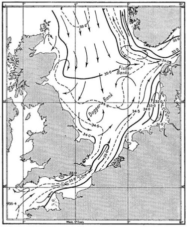
FIG. 8
The varying saltness (31.0 0/00 to 35.4 0/00) of the surface waters and the main circulation typical of the North Sea and English Channel in winter. Drawn from a chart kindly provided by Commander J. R. Lumby, of the Fisheries Laboratory, Lowestoft.
Just as the pendulum is deflected in relation to the objects in the hall, so any body of water in motion tends to be deflected to the right in the northern hemisphere and to the left in the south in relation to the surrounding land masses and the ocean floor; account has to be taken of it in every practical treatment of tides, wind drifts and ocean currents. Whenever a water-mass meets an obstruction, either a mass of land or an opposing water-mass, it will, other things being equal, turn to the right in the north rather than to the left, and vice versa in the south. There is another important effect. We have seen how through differences in temperature and saltness the water varies in density; the lighter water will naturally be on top. In a current system the water of a particular density—say the lightest water at the top—is not lying in a layer of uniform depth; owing to the earth’s rotation the lighter water is pushed more to the right-hand side of the current stream than the heavier water, so that imaginary surfaces separating waters of different density are not horizontal but tilted. It is from a consideration of the deflection of waters of different densities that the speed and direction of ocean currents can be mathematically worked out as mentioned earlier in the chapter.
With this slight introduction, intended merely to give an idea of the kind offerees at work to produce the circulatory ocean-systems, we may now briefly review the main streams of water in the seas around our coasts. Fig. 8, is based on the account by Comd. J. R. Lumby (1932), hydrologist at the Fisheries Laboratory, Lowestoft, with a small revision which he has kindly made in the drawing for this figure. The water in the North Sea and English Channel is slightly less salt than the Atlantic Ocean water; it is typically coastal water diluted by freshwater drainage from the land. The Baltic has a much lower salinity still. A stream of Atlantic water flows into the North Sea from the north, mainly passing round to the east of the Shetland Islands to flow due south and not usually entering between the Orkneys and the Shetlands as was originally thought; a less powerful stream flows up the English Channel and enters it from the south. The northern influx is generally thought to flow on a broad front down the middle of the North Sea forming, as it goes, swirls off the coast of Scotland especially in the Moray Firth and in the region of the Firth of Forth. Dr. J. B. Tait of the Scottish Fishery Department has in recent years, however, put forward the view (1952) that the main streams are much narrower than formerly supposed—more like rivers flowing in the sea. Which is the correct view is at present by no means certain; some evidence from plankton distribution appears to support one view and some the other. Just before reaching the Dogger Bank the main stream, whether broad or narrow, appears generally to divide into three branches: one running south-westerly, another south-easterly and a third turning east to enter the Skagerrak. The south-westerly and south-easterly branches form large swirls in the southern North Sea as they meet the stream of water entering from the Channel. Another smaller swirl is formed outside the Skagerrak as the stream entering on the southern side meets the stream flowing out of the Baltic on the northern side.1 The stream entering the North Sea from the Channel flows north-eastwards past the Dutch and Danish coast and some of it joins the stream going into the Baltic. Most of the North Sea is shallow, but there is a deep hollow running up the western coast of Norway to the north; it is along this Norwegian trough that the water leaves the North Sea—the less saline water from the Baltic on the top and the bulk of the North Sea water proper in the deep channel below.
The extent of the inflow of Atlantic water varies from year to year; such variations affect the distribution of the plankton and are likely to influence the distribution of the herring shoals which depend upon the plankton for food. In some years of exceptional influx numbers of plankton animals usually only found in the more open ocean make their appearance in the northern North Sea. There is some evidence to support the view that it is the pressure of this water from the north (produced by the main wind systems) which, apart from the occasional effects of local winds already referred to, controls the inflow of Channel water into the southern North Sea. If the pressure from the north is high it seems that the Channel flow is reduced; if it is weak then a larger influx from the Channel seems to take place. It is in the study of this inflow into the northern North Sea that the charting of the relative movements of certain Atlantic plankton animals in different years can be most helpful. We shall see in a later chapter (see here) how, by the use of plankton-recording machines towed at monthly intervals by commercial steamships on regular routes, we can compare the areas of invasion of these more oceanic forms in different months and years. We shall find that not only does the extent of the Atlantic inflow vary from year to year, but the time of the advance of typical invading organisms will vary: in some years it may be a month earlier or later than in other years. There is an interesting suggestion now being investigated that the time of the appearance of the shoals of herring at different points down the east coast of Scotland and England, and consequently the time of the different fisheries, may be earlier or later in different years depending on whether this Atlantic inflow is earlier or later.2 Whether this indication—it is no more at the moment—will be proved correct or not, there can be no doubt that the fluctuations that are found to occur in the water movements round our islands must have a profound effect upon the fish and other life inhabiting our seas.
A more definitely established connection between water changes and fisheries has been demonstrated at the western entrance to the English Channel. The water of the greater part of the Channel is like that of the southern North Sea—coastal water which is less saline and less rich in plankton than the Atlantic water that flows into it. This more coastal water can readily be distinguished from the more oceanic water by the presence of certain of these indicator plankton species—particularly two species of Sagitta, the slender transparent arrow worm shown in Plate IX; Sagitta setosa being found in the coastal water and Sagitta elegans in the more oceanic water.3 The boundary between the two waters formerly used to lie somewhere in the region of Plymouth where sometimes the plankton would have elegans predominating in it and sometimes setosa) during the investigation up to 1929 it was more usually elegans, indicating Atlantic water richer in phosphates and other nutrient salts. The importance of these salts in the economy of the sea will be discussed in Chapter 4. Since 1929 the boundary between elegans and setosa water has lain much further to the west so that the water off Plymouth has been of the coastal type and much poorer in plankton. Since this date there has also been a marked reduction in the number of young fish of many kinds present in the plankton as well as a change in the herring fishing; since that time the herring which used to visit the Plymouth area around Christmas have not turned up in their usual numbers so that this winter fishery, once quite a prosperous one, now no longer takes place. An excellent account of this trend was given by the late Dr. Stanley Kemp in his presidential address to the Zoology Section of the British Association in 1938. More recently some other interesting differences between the elegans and setosa water have been discovered; these will be referred to later when the various chemical constituents of the water are being considered (see here).
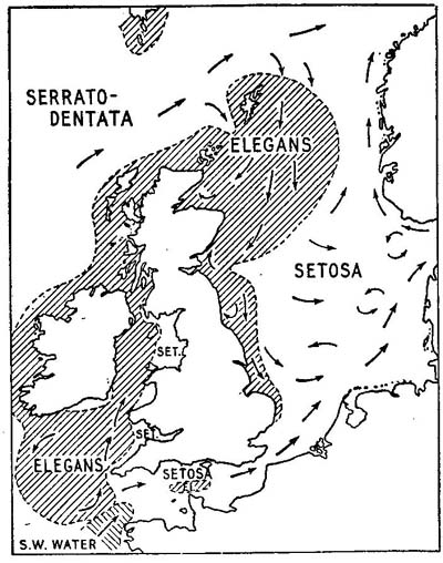
FIG. 9
Map showing the distribution of three kinds of water round Great Britain each characterised by a different species of the arrow-worm Sagitta: serratodentata in open ocean water, setosa in coastal water and elegans in oceanic water mixing with the coastal water. The conditions are those which might be expected in the autumn of a year with a strong Atlantic influx into the North Sea from the north. From Russell (1939), but modified in the north in the light of more recent surveys and with some other details omitted.
Mr. F. S. Russell, the present Director of the Plymouth Laboratory, who carried out these studies on Sagitta (1935, 1936) and young fish (1940), made cruises to trace the boundaries between the different kinds of plankton. He has told me how very abruptly one type of water may give place to another. On one occasion he has said it was even possible to place the ship across the very margin between them, so that elegans water could be sampled from the bows and setosa water from the stern! Fig. 9, shows the general distribution of the elegans and setosa water round the British Isles as it might be expected in the autumn of a year in which there is a strong influx of Atlantic water into the North Sea from the north; it is taken from another of Mr. Russell’s papers (1939). These different waters may also be sometimes discernible by a difference in their colour, a contrast of shades of blue and green making a line across the sea. In 1923, when on the staff of the Fisheries Laboratory at Lowestoft, I acted as observer in some attempts to locate shoals of herring and mackerel from the air. In flying from Plymouth to the western mackerel grounds we passed over a sharp line separating the green water of the Channel from the deep blue of the Atlantic; it ran on a slightly irregular course from the Lizard to the south-west as far as we could see to the distant horizon. Then while circling over the mackerel area we saw another equally definite boundary running from Land’s End towards the Scilly Isles separating the deep blue water from a more brown-green area lying to the north. At that time I could not interpret that striking pattern of colour contrasts; now on looking at Mr. Russell’s maps I have little doubt that the blue area I saw was oceanic elegans water lying between the setosa water of the English Channel and that of the Irish Sea. Fig. 10 shows a comparison between my sketch of these colour boundaries, which was published in the official report (Hardy, 1924a) and Mr. Russell’s maps of the distribution of the setosa and elegans water in the same area but in different years (Russell, 1935, 1936). If these marked colour-changes can be correctly interpreted we may in the future find aircraft being used to make rapid surveys of the surface conditions in relation to the fisheries. The actual experiments in spotting shoals offish were not successful in these waters; in the southern North Sea the water was too opaque with the large amount of sediment constantly stirred up by tidal currents running over sand and mud banks; at the western entrance to the Channel the ocean surface was too much broken up by waves into light and shade to allow of any observations below it.
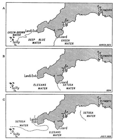
FIG. 10
Well defined areas of blue and green water (A) seen from the air during mackerel spotting tests off Cornwall in 1923 drawn from the chart by Hardy (1924) and compared (B and G) with the distribution of western and Channel water as indicated by the arrow-worms Sagitta, elegans and setosa, charted by Russell (1935 and 1936).
In the shallower waters—especially in the southern North Sea—we must not forget the influence of the tidal streams just mentioned; they may have a most profound effect in modifying the action of the main currents, especially when they vary so enormously in their force between spring and neap tides. At spring tides in certain places a mass of water may be moved for some thirty or forty miles in each direction.
The movements of water in the Irish Sea are also dominated by tidal currents; these flow into it from both ends and follow the general direction of the coast lines. Professor K. F. Bowden, who has given us such an excellent account of these tidal streams (1953), writes, “Knowledge of the non-tidal drift, however, is much less certain and is based on indirect evidence. It was recognised at an early date that the distribution of salinity indicated a north-going drift and in 1907 Knudsen estimated that the rate of flow was such that the water in the Irish Sea would be completely renewed in a year.” After saying that “this implies a flow through the Dublin-Holyhead channel at an average rate of just over a kilometre a day,” he later stresses that, although there seems little doubt about this average northward movement, “its magnitude, its variations and the degree of its dependence on the wind are still uncertain.”
We have now dealt with the main water movements round our islands; later in the book we shall see instances of more local effects and how upwellings and the mixing of waters may be important in producing a richer plankton. I will end the chapter by referring to some surprising and significant plankton records being made by Dr. J. H. Fraser (1952e, 1955) of the Scottish Fishery Laboratory at Aberdeen. In some years, over a wide area to the north of Scotland, he finds plankton animals which we should more usually associate with the latitudes of the Mediterranean; they indeed indicate a very unexpected movement of water. It now appears that some of them may in fact actually have come from the Mediterranean Sea itself.
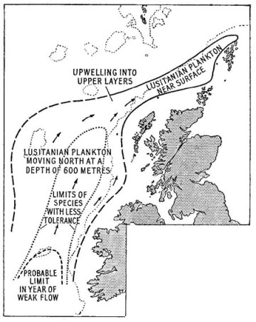
FIG. 11.
A chart showing the northward flow of the ‘Lusitanian’ plankton; kindly provided by its discoverer Dr. J. H. Fraser of the Scottish Fishery Laboratory, Aberdeen.
It has long been known that a surface stream of Atlantic water flows eastwards through the Straits of Gibraltar and that this influx is balanced by an outpouring (at a lower level) of Mediterranean water of very high salinity; this spreads out from the Gulf of Gibraltar underneath the North Atlantic water and some of it is carried north up the edge of the European continental shelf. This movement is well summarised in Sverdrup, Johnson and Fleming’s important book The Oceans (1942, pp. 646, 685–6) which, for the serious student, gives such an excellent account of the main results of modern oceanography. Dr. L. H. N. Cooper of the Plymouth Laboratory has recently (1952) made a study of the distribution of this water to the west of the British Isles as it continues northward below the Atlantic water at a depth of some 600 to 1,200 metres. How far north it goes seems to vary greatly in different years; in some it appears to go no further than the west of Ireland, but in other years it flows onwards to upwell and spread over the continental shelf. Its course has been followed by Dr. Fraser by finding its typical but exotic fauna in his plankton nets; to the west he finds it deep down—but let me quote from his recent paper.
“It apparently follows the edge of the Hebridean Continental shelf, mixing on its western edge with open oceanic water, and upwells somewhat on the east side to overflow and mix with coastal water on the shelf. In some years this current may not reach Scotland or is too weak to be recognised, but on occasions it is sufficiently strong to continue into the South side of the Faroe Channel, though it only rarely penetrates beyond the north of Shetland. Frequently, however, it mixes with the coastal water on the shelf and the resulting mixture floods the area to the west of Orkney and often passes through the Fair Isle-Orkney Passage into the Moray Firth area.”
How lucky we are to have such a remarkable current carrying its rich and southern life far below the surface and then spreading it out, as it were, on our northern doorstep for our examination. Fraser calls this a planktonic ‘Lusitanian fauna’ and lists no fewer than 43 species characteristic of it; he has kindly prepared for me a chart of its typical distribution which is reproduced in Fig. 11. Through his recent publications I have been able to add to my account some very interesting animals which I shall be describing in Chapter 7 and Chapter 8 and which hitherto I should never have dared to include as inhabitants of British waters. He defines his Lusitanian fauna as that which “originating in the outflow from the Mediterranean, has become modified by admixture with fauna from the area between the Azores and Bay of Biscay.” This work is an outstanding example of the importance of natural history in helping us to have a better understanding of the physics of the sea. I will give a final quotation from his work:
“The whole of this oceanic system to the north and west of Scotland overlies a south tending mass of artic or boreal water. The main flow of this water mass is to the west of Faroe from whence it thrusts southwards in deep water (below about 1,000m.), but part also penetrates the Faroe Channel where it is checked by the Wyville Thomson Ridge.4 Although this water affects the inflowing system where it mixes at its interface it is not of such importance as are the more massive cold water currents on the other side of the Atlantic.
“Each of the above water masses has a typical plankton fauna (see Russell 1939, and earlier works), which varies within certain limits, in the abundance and in the proportions of its constituent species from year to year. As these organisms are transported further from their natural habitat they gradually die as their limit of tolerance is reached, and they are replaced by other species through mixing either with other oceanic streams or with coastal water. The fauna of an incoming water mass thus gradually changes along its length; for example, few of the oceanic species noted off Scotland normally reach north-western Norway (Wiborg 1954). The degree of survival of the original fauna gives a measure of the purity of the inflow, and the relative life of the species less tolerant to various factors may give an indication of the type of dilution or change involved.”
1 A valuable review of the changes in the southern North Sea, clue to variations in the influence of the low salinity water from the Baltic and that of the higher salinity water from the Channel, has been made by Lucas and Rae (1946).
2 This will be referred to again in chapter 15, see here.
3 The difference between the two is shown in Fig. 42.
4 see here.
CHAPTER 3 PLANTS OF THE PLANKTON

HAVING DISCUSSED the movement of the waters it might perhaps seem more logical to pass on at once to consider other physical characters of the sea and something of its chemistry before proceeding to deal with any of the life within it. On the other hand, since the plants of the open sea are so intimately dependent upon their physical and chemical background it will be more interesting if we know what kind of plants we are dealing with before we actually discuss the conditions which are most favourable for their growth.
The vegetation of the open sea must be floating freely in the water in order to be sufficiently near the surface to get enough light; the great difference between it and that of the coasts or land, is that it consists entirely of plants of microscopic size. They are, as we have already seen, part of the plankton: the phytoplankton. Each is composed of just one unit of life—a single cell—instead of being made up, as are the larger plants, of a vast number of such units. Instead of having various kinds of cells specialised to perform different functions in organs such as roots, stems, leaves and reproductive bodies, all these activities of life are carried out by just one highly organised unit. It does at first sight seem strange that there should not be even a few larger plants adapted for such a floating existence. There is the famous Gulf-weed Sargassum which, buoyed up by the little floats upon its fronds, is found in masses drifting round that great eddy of the tropical Atlantic—the Sargasso Sea; this however is not a true open-ocean plant for it has been broken away by wave action from the coasts of Central America and the West Indies. It continues to grow for a long time but never produces reproductive organs as it does when attached to its native rocks. In our own waters we may sometimes meet with patches of bladder-wrack, Fucus vesiculosus, torn from the sea-shore by storms and floating in the same way. They are but mutilated stragglers, out of place and lost in the open sea.